Last reviewed and updated: March 2026
Axe Edge Moor is one of the most remote and windswept landscapes in the Peak District. Located near Buxton in the south-western part of the national park, this high moorland plateau is the source of several important rivers including the River Dove.
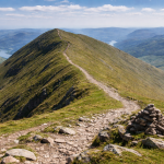
Although it lacks the dramatic ridges of places like Mam Tor or Kinder Scout, Axe Edge Moor offers something different — a vast open landscape with sweeping views across the surrounding countryside.
For walkers who enjoy quieter routes away from busy tourist hotspots, Axe Edge Moor provides a peaceful and atmospheric hiking experience.
Axe Edge Moor Walk Overview
Distance: 7 km (4.3 miles)
Difficulty: Moderate
Time: 2–3 hours
Start point: Axe Edge Moor Lay-by (A53)
Axe Edge Moor Route Description
The Axe Edge Moor walk usually begins at one of the roadside lay-bys along the A53 Buxton to Leek road, where several footpaths lead directly onto the moor.
From the lay-by, follow the public footpath that heads away from the road and onto the open moorland.
Within a few minutes the landscape opens up dramatically. The terrain here is very different from many other parts of the Peak District, consisting mainly of grassy moorland, peat bogs and gently rolling hills.
Continue following the path as it leads towards the high ground of Axe Edge Moor.
The trail is generally easy to follow but can become muddy in places, especially after wet weather. Good footwear is recommended as some sections cross soft ground.
As you climb gradually onto the plateau, the sense of space becomes more noticeable. The surrounding landscape stretches out in every direction, giving the walk a remote and peaceful atmosphere.
Axe Edge Moor is also historically significant as it forms the source of several important rivers including the River Dove, River Manifold, River Dane and River Goyt.
This watershed location is one of the reasons the area has long been considered geographically important within the Peak District.
Continue walking across the moor following the main path as it gently rises and falls across the plateau.
On clear days you may be able to see distant hills including Kinder Scout, Shining Tor, and parts of the Staffordshire Moorlands.
The walk itself is not technically difficult, but the open landscape means the weather can feel more exposed than in lower valleys.
Eventually the route loops back towards the road, following another footpath that gradually descends from the plateau.
The return path reconnects with the starting point near the A53, completing the circular route.
Although the walk is relatively short, the wild moorland scenery makes Axe Edge Moor feel much more remote than its distance suggests.
Best Time to Walk Axe Edge Moor
Axe Edge Moor can be walked throughout the year, but conditions are usually most enjoyable between spring and autumn.
Spring brings fresh greenery to the moorland and often provides calmer weather conditions.
Summer offers longer daylight hours and clearer views across the surrounding countryside, although the exposed plateau can still feel windy.
Autumn is another excellent time to explore the moor. The landscape often takes on warm brown and golden tones which create beautiful scenery across the hills.
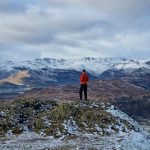
Winter walks can be particularly atmospheric, especially when frost or snow covers the moorland. However, the exposed terrain means the weather can feel harsh during colder months.
Checking the weather forecast before heading out is always recommended.
Tips for the Axe Edge Moor Walk
Axe Edge Moor is a relatively straightforward hike, but a few simple tips can help make the walk safer and more enjoyable.
• Check the weather forecast carefully. The moorland plateau is very exposed to wind and rain.
• Wear waterproof walking boots. Some sections of the trail can be muddy or boggy.
• Bring a map or GPS. Paths across open moorland can sometimes be less obvious.
• Carry extra layers. Weather conditions can change quickly at higher elevations.
• Start early in the day. Visibility is often better earlier in the morning.
Despite its relatively gentle terrain, the open landscape means walkers should still be prepared for changing weather conditions.
Recommended Gear for This Walk
Because Axe Edge Moor is an exposed moorland hike, wearing suitable hiking gear is especially important.
A good pair of waterproof walking boots provides grip and protection from muddy ground. If you’re looking for recommendations, check out our guide to the Best Walking Boots for UK Trails.
Weather in the Peak District can change quickly, particularly on open moorland. Carrying a waterproof jacket is always recommended. Our guide to the Best Waterproof Hiking Jackets UK highlights some excellent options.
Comfortable hiking clothing can also make longer walks more enjoyable. Our guides to the Best Walking Trousers UK and Best Walking Socks UK include several reliable options for UK hiking conditions.
Finally, a small backpack makes it easy to carry water, snacks and extra layers. Our guide to the Best Day Hiking Backpacks highlights some great choices for day hikes.
Axe Edge Moor Walk FAQs
How long is the Axe Edge Moor walk?
The typical Axe Edge Moor walk is around 7 km (4.3 miles) and usually takes 2–3 hours to complete.
Is Axe Edge Moor suitable for beginners?
Yes, although the terrain can be muddy in places and the exposed weather conditions mean walkers should still be prepared.
Where do you park for Axe Edge Moor?
Many walkers start the route from roadside lay-bys along the A53 between Buxton and Leek.
Why is Axe Edge Moor important?
Axe Edge Moor is known as the source of several rivers including the River Dove and River Goyt.